دانلود نرم افزار RIVERMorph
بازسازی جریان (Stream restoration) یا ترمیم رودخانه که گاهی اوقات نیز با نام بازسازی رودخانه مطرح می شود، شامل مجموعه ای از اقداماتی است که به بهبود وضعیت سلامت محیط یک رودخانه/جریان آب کمک می کنند. هدف این گونه فعالیت ها بازگردانی وضعیت اطراف رودخانه به حالت طبیعی آن است و اقداماتی در زمینه ی حمایت از تنوع زیستی، احیا رودخانه، مدیریت سیل/سیلاب و توسعه چشم انداز و ... را شامل می شود.
نرم افزار RIVERMorph با هدف کمک به متخصصینی که در زمینه ی ترمیم رودخانه فعالیت دارند طراحی شده است تا در انجام این گونه پروژه ها بتوانند در هزینه ها و زمان خود صرفه جویی نموده و مدیریت بهتری بر کارها داشته باشند. رابط کاربری این نرم افزار به گونه ای طراحی شده است که امکان دسترسی سریع به داده های ذخیره شده را برای کاربران فراهم می کند. کاربرا می تواند اطلاعات و داده های مرتبط با هر رودخانه را در پایگاه داده ذخیره نموده و دسته بندی کند. با استفاده از مجموعه ابزارهای ارائه شده در این نرم افزار می توان میزان توزیع ذرات در بستر رودخانه را با استفاده از روش های آمار و احتمال اندازه گیری نموده و تجزیه و تحلیل کرد.
قابلیتهای کلیدی نرم افزار RIVERMorph:
- رابط کاربری کاملاً گرافیکی و قابل فهم
- ذخیره داده ها به صورت گروه بندی شده
- دسترسی سریع به اطلاعات ذخیره شده
- وارد کردن فایل های HEC و یا Copy/Paste داده ها از حافظه کلیپبورد سیستم
- اندازه گیری های مختلف پارامترهای ژئومورفیک از گراف نمایه (profile graph)، مانند فاصله pool-to-pool و طول استخر (pool length)
- استفاده از سیستم Rosgen Classification برای گروهبندی ویژگی ها و اطلاعات مربوط به هر جریان آب/رودخانه
- ارائه ابزارهای Gage Analysis
- تجزیه و تحلیل فرکانس سیلاب
- و ...
دانلود RIVERMorph v5.2.0 Professional - نرم افزار بررسی وضعیت رودخانه و جریان آب
| 💿 نام نرم افزار | RIVERMorph |
| 📌 شماره نسخه | v5.2.0 Pro |
| 📁 دسته بندی | جغرافیا |
| 💾 حجم فایل | 94 مگابایت |
| 📅 تاریخ به روزرسانی | 1397/6/11 |
| 📊 تعداد دانلود | 5,493 |
| ❤️ هزینه دانلود | رایگان و نیم بها |
| 💡 آموزش نصب و فعال سازی | ✔️ |
سوالات متداول
نرم افزار RIVERMorph چیست؟
نرم افزار نگهداری و ترمیم بستر رودخانه ها و جریان های آبی به همراه تمام ابزارهای نرم افزاری موردنیاز مهندسین این حوضه
آخرین ورژن نرم افزار RIVERMorph را از کجا دانلود کنم؟
برای دانلود نرم افزار RIVERMorph به طور رایگان و با ترافیک نیم بها (در ایران) روی این لینک کلیک کنید.
آموزش نصب نرم افزار RIVERMorph چگونه است؟
راهنمای نصب نرم افزار RIVERMorph در این صفحه درج شده است.
کلمات کلیدی RIVERMorph: Stream restoration, design streams, River, geomorphic, Analysis, RIVERMorph, نرم افزار, مهندسی, رودخانه, مدیریت آب, بازسازی رورخانه, آنالیز جریان آب, جغرافیا, آنالیز اطلاعات جغرافیایی, ریور مورف, نرم افزار مدیریت وضعیت رورخانه, نرم افزار آنالیز وضعیت آب, تجزیه و. تحلیل جریان های آبی, نرم افزار مهندسی آب, مدیریت بحران جریان های آبی, نگهداری جریان های آبی, تجزیه و تحلیل اطلاعات مربوط به رود, آنالیز وضعیت آب های جاری, ,
RIVERMorph full software collection,
قهرثقپخقحا , قهرثقئخقحا ,دانلود RIVERMorph نرم افزار بررسی وضعیت رودخانه و جریان آب,
How to crack RIVERMorph,
طریقه/روش/راهنمای کرک,
Torrent/Usnet/Buy,
Setup,
Install,
دانلود رایگان نرم افزار,
P30Download,
Danlod/Danload/Donload,
nhkg,n kvl htchv,
Download RIVERMorph Software,
for windows,
Trial,
last Version/Edition,
New Version,
Update,
Free Full Licensed,
Repacked,
Direct Download Link (DDL),
Crack,
Get RIVERMorph,
Keygen,
Patch,
Serial,
Portable,
برنامه RIVERMorph 5.2.0 Pro,
Stream restoration software with virtually every design function you need built into a single program.,
قهرثقپخقحا, قهرثقئخقحا,خرید RIVERMorph,
به روز ترین ورژن,
آخرین ورژن,
آخرین نسخه,
جدیدترین ورژن,
جدیدترین نسخه,
5.2.0 Pro,
داونلود/دانلد/تورنت
نرم افزار نگهداری و ترمیم بستر رودخانه ها و جریان های آبی به همراه تمام ابزارهای نرم افزاری موردنیاز مهندسین این حوضه,
تحميل,
دریافت,
پی سی,
پی 30,
سافت ور,
تریال,
سوفت ور,
مجانی,
RIVERMorph 5.2.0 Pro Download
RIVERMorph significantly reduces the time required to access, analyze and design streams by putting tools you need right at your fingertips.
RIVERMorph is designed to streamline time consuming tasks performed by river restoration professionals. The interface is easy enough to use that most people can start working with the software right after installation. RIVERMorph manages data in a friendly "River Tree View" that allows users to visualize the entire river and reach the database at a glance. A Microsoft Outlook®-style toolbar groups common commands into a familiar and easy-to-use toolbox. Tabbed forms, hyperlinks, and modern controls are used to help make this interface quick, easy and fun.
Here are some key Features of "RIVERMorph":
GUI
RIVERMorph features a state-of-the-art graphical user interface that is user friendly & allows quick access to stored data. RIVERMorph stores river data in a database referenced by river name and reach name. River data is stored under a number of categories, all accessed through the data tree view in the left of the screen. Calculation tools are accessed through the toolbar buttons beneath the tree view. New rivers, reaches & data sets are all added within the data tree view.
Cross Section Tool
Cross section data can be entered directly, copied from the Windows Clipboard, or imported from a HEC file. RIVERMorph also provides a screen for entering survey data and performs data reduction for plotting the section. RIVERMorph graphs the cross section data loaded into the current table. Bankfull hydraulic geometry is displayed based on bankfull indicators identified in the survey. A slide tool built into the cross section form allows the user to adjust the bankfull elevation and quickly recalculate bankfull dimensions.
Profile Tool
Longitudinal profiles are entered using a similar format to the Cross Section Tool. The graph provides options for smoothing water surface profiles due to data collection errors, and calculates regression lines through data points selected by the user. Average reach, riffle, run, glide and pool slopes are calculated from the graph using a variety of tools and can be stored directly into the database. RIVERMorph also allows the user to quickly measure a variety of geomorphic parameters from the profile graph, such as pool-to-pool spacing and pool length.
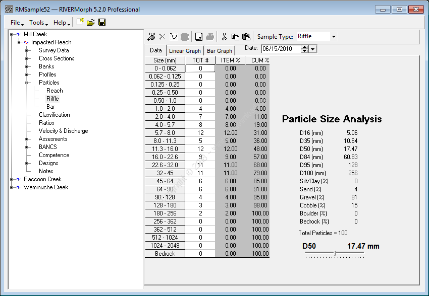
Channel Materials
The Channel Material tool calculates the particle size distribution of bed materials using data based on the Wolman pebble count method or data from sieve analyses. The percentage of various sizes of particles comprising the bed materials is computed and a slider tool can be used to determine the size of particle corresponding to a user defined percent finer. Critical data obtained from the particle size distribution analysis is stored in the RIVERMorph database and can be easily retrieved for stream classification and sediment transport validation calculations. Results from the analysis can be graphed and printed.
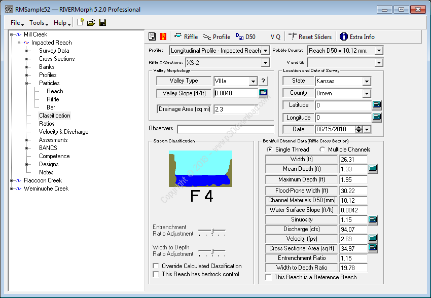
Stream Classification
RIVERMorph determines stream classification using the Rosgen Classification system. Data for stream classification can be entered directly into RIVERMorph or information stored in the database can be accessed to complete the classification. By checking the 'Reference Reach' tab in the upper left-hand corner, data from a particular reach can be stored as a reference reach for use with Natural Channel Design.
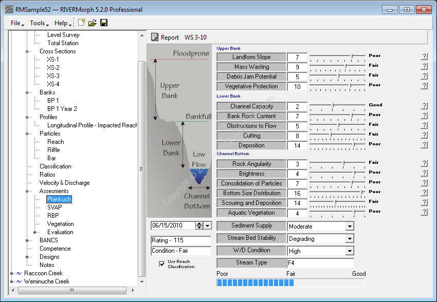
Pfankuch Channel Stability
The Pfankuch Channel Stability assessment was developed to rate the relative stability of a channel based on a number of parameters. The user completes the Pfankuch Channel Stability form included in RIVERMorph and the program calculates an overall Pfankuch rating. Using the Pfankuch rating, plus stream classification information, an overall reach condition rating is easily determined.
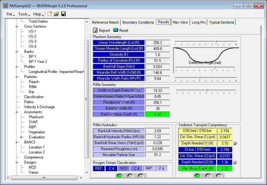
Natural Channel Design
RIVERMorph performs Natural Channel Design (NCD) using Reference Reach data entered by the user, or site specific data and sediment transport competency calculations. The user selects the Reference Reach, enters site-specific design information from the RIVERMorph database, and sets up a new NCD that will be stored as a Reach in the database. In developing the NCD, RIVERMorph allows users to set site constraints for the NCD Reach. Through the NCD, RIVERMorph shows the new channel dimensions and classification results, and creates cross section and profile summaries that users can see. Meander geometry is plotted by sine-generated functions for each meander wavelength.
Resistance Equations
Sometimes an NCD will require some portions of the channel to be steeper and have higher velocities; such as riffle lengths in a C4 stream type. A good way to calculate velocities in riffles is to use Manning's Equation with a roughness coefficient determined from bed materials and flow depth. Other options such as the Cowan Equation, published data stratified by stream type and references from photographs, are available for calculating roughness coefficients for the Manning Equation. Additionally, RIVERMorph includes equations for calculating velocity based on the Chezy formula, the Darcy-Weisbach formula, and based on standard pipe flow equations.
Regime Equations
RIVERMorph provides industry accepted regime equations as well as allowing the user to create new equations for data entered into the RIVERMorph database. The user simply drags a geomorphic variable from the left side of the screen into the equation and all available equations using those variables are loaded from the database. The primary regime equations in RIVERMorph were published in a G. P. Williams paper titled "River Meanders and Channel Size" (1986).
Gage Analysis
USGS gage data can be downloaded, displayed and analyzed by RIVERMorph. The program facilitates a Log-Pearson Flood Frequency analysis used to calibrate bankfull at USGS gaging stations. Using this tool, the discharge applicable for a variety of return intervals can easily be calculated. Other gage features include hydraulic geometry plotting and regional curve creation.
More info ( ↓ open / close ↑ )